


The Dolomites are a range of pale limestone peaks in northeastern Italy, spread across South Tyrol, Trentino and the Veneto. They are worth the trip for jagged skylines that glow pink at dusk, emerald lakes, alpine meadows dotted with huts, and a mix of Italian, Austrian and Ladin culture you will not find anywhere else in the Alps.
This Dolomites travel guide covers the headline sights (Lago di Braies, Tre Cime di Lavaredo, Seceda, Alpe di Siusi), the two big resort valleys, how hut-to-hut walking and via ferrata work in general terms, when to go, and how to manage without a car. For more ideas around the country, browse our Italy travel guides.
What and Where Are the Dolomites?
The range takes its name from the French geologist Déodat de Dolomieu, who described its distinctive rock in the late 1700s. The stone is dolomite, a carbonate that weathers into sheer walls, towers and pinnacles. Marmolada, at 3,343 meters, is the highest summit.
UNESCO added the Dolomites to the World Heritage List in 2009. The listing is a serial property of nine separate mountain systems rather than one block, which is why there is no single "Dolomites National Park" and no single center. The area is shared by five provinces: Bolzano, Trento, Belluno, Pordenone and Udine. In practice you pick a base valley and explore around it. The official UNESCO World Heritage page has the full description.
A Region with Three Cultures
South Tyrol was part of Austria until after the First World War, so place names come in two or three languages. The same lake is Lago di Braies in Italian and Pragser Wildsee in German; the plateau above Ortisei is Alpe di Siusi or Seiser Alm. Expect German to be the first language in many South Tyrolean villages, Italian further south and east, and Ladin in the central valleys. Everyone in the tourist trade copes with English.
Lago di Braies: The Postcard Lake
Lago di Braies sits at 1,496 meters in the Prags Dolomites, and it is the lake you have seen on a thousand screensavers. It is about 36 meters deep at the deepest point, ringed by forest and overlooked by the Croda del Becco. A path circles the shore: wide and flat on the west bank, narrower and steeper on the east, where it can be closed in winter because of avalanche risk. Plan on about an hour at a relaxed pace.
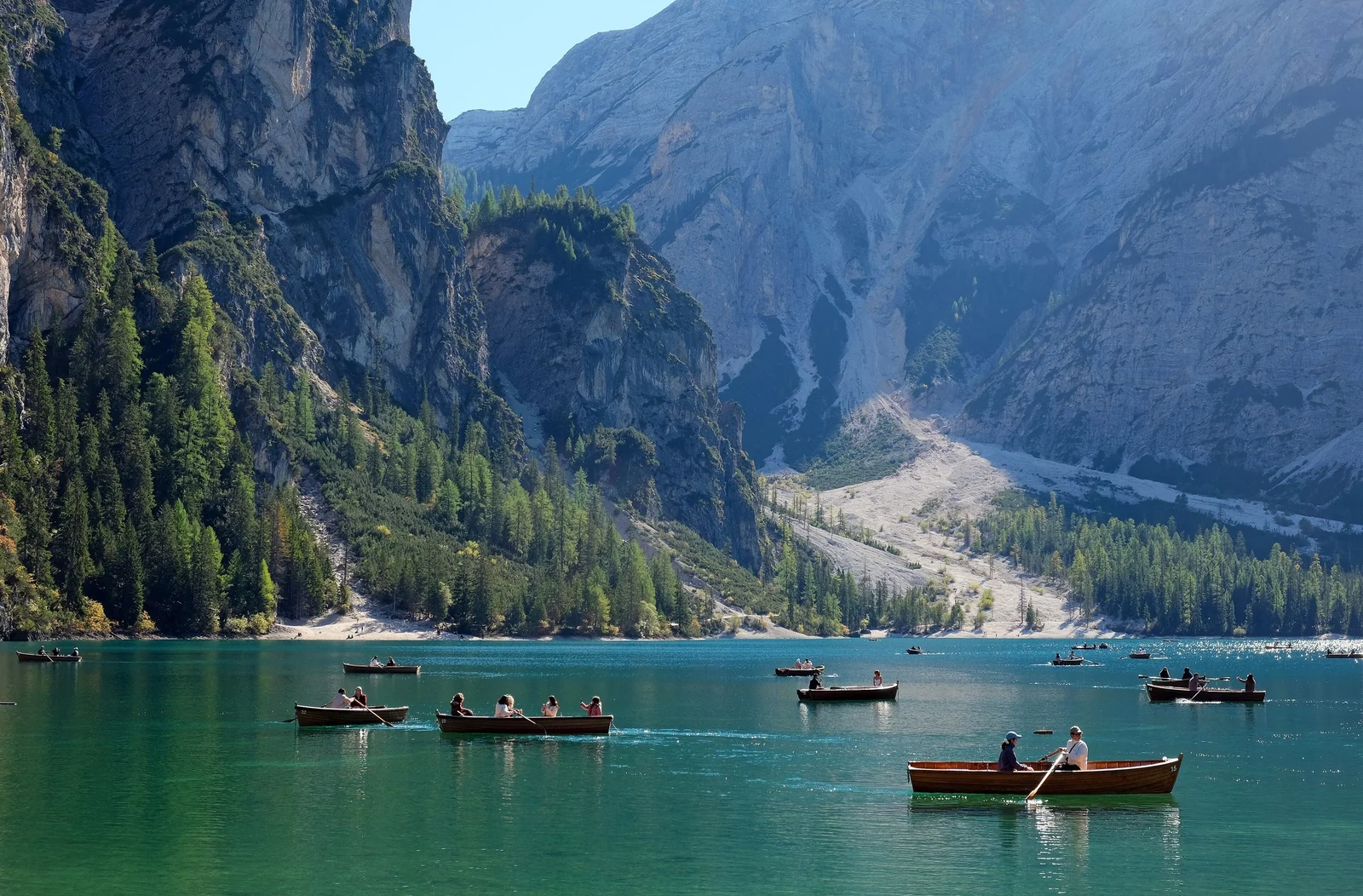
The catch is crowds. In summer the lake is one of the busiest spots in the Dolomites, and vehicle access on the road into the Braies valley has been restricted on peak days. Rules and booking systems for parking change, so check the local tourism pages before you drive. Better still, arrive early, come in late afternoon, or visit in June or September. It is also the starting point of the long-distance Alta Via 1, covered below.
Tre Cime di Lavaredo: The Iconic Three Peaks
The Tre Cime (Drei Zinnen in German) are three standalone towers in the Sexten Dolomites: Cima Grande at 2,999 meters, Cima Ovest at 2,973 and Cima Piccola at 2,857. Paul Grohmann and two guides made the first ascent of Cima Grande in 1869. Today the towers belong mostly to climbers, while everybody else walks around them.
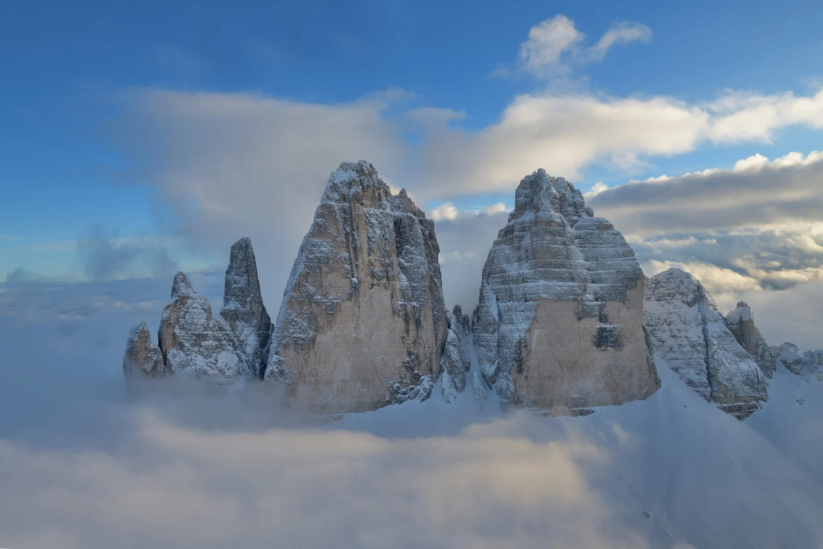
The Classic Loop
Most visitors start at Rifugio Auronzo, roughly 2,300 meters up, which you reach by a toll road from Lake Misurina. From there the circuit around the base of the towers is a half-day hike on wide, well-marked paths, passing Rifugio Locatelli, with the north faces coming into view. It is not technically hard, but it is high, exposed to weather and busy, so bring layers and start early.
The toll road and parking arrangements, plus any bus alternatives, are set locally and change, so check before you go. Lake Misurina, at the foot of the road, is a pleasant stop in its own right.
Seceda and Val Gardena
Val Gardena (Gröden in German, Gherdëina in Ladin) is the most photographed of the big resort valleys, with the villages of Ortisei, Santa Cristina and Selva. Its showpiece is Seceda, a 2,519-meter ridge in the Puez-Odle Nature Park, where the serrated Odle peaks drop away on one side and grass slopes roll gently down on the other.
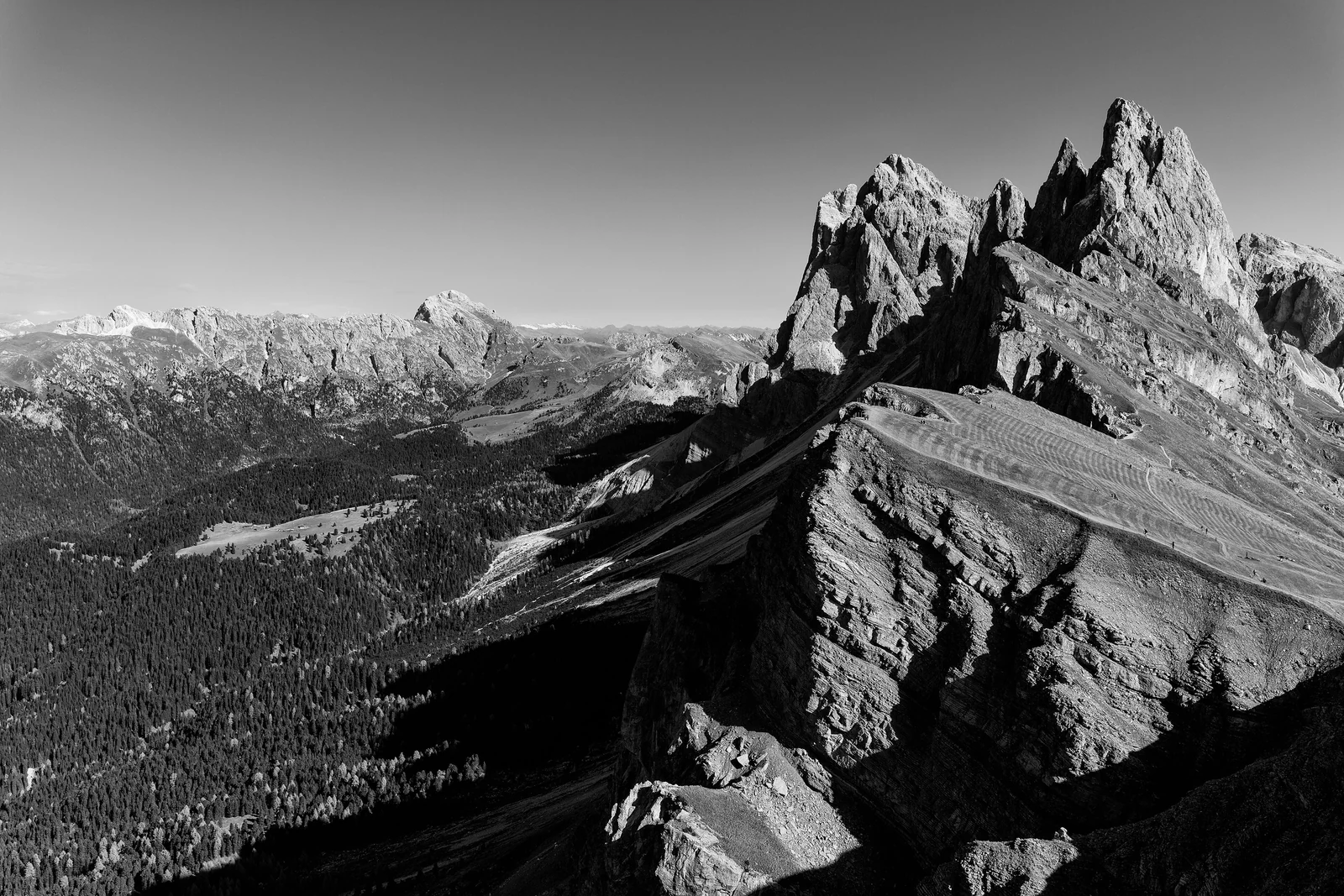
You reach Seceda by cable car from Ortisei, or from the Santa Cristina side via the Col Raiser lift. The summit cross is a short walk from the top station, and the panoramic viewpoint a little farther along the ridge is the shot everyone wants. Lifts operate in the warm season only, so check opening periods and fares on the Val Gardena tourism page. Go early: the light is softer and the queue shorter.
Ortisei itself is the valley's main town, with a pedestrian center, woodcarving workshops that reflect a long local craft tradition, and good access to buses and lifts. Selva is the base most skiers prefer for its direct link into the Sella Ronda circuit.
Alpe di Siusi: Europe's Largest High Meadow
Alpe di Siusi (Seiser Alm) is a plateau of about 52 square kilometers at roughly 1,700 to 2,350 meters, widely described as the largest high-altitude alpine meadow in Europe. It lies between Val Gardena and the Sciliar massif, with the Sassolungo group to one side. It is the gentlest place in the Dolomites: wide paths, grazing cows, wooden huts and wildflowers in early summer.
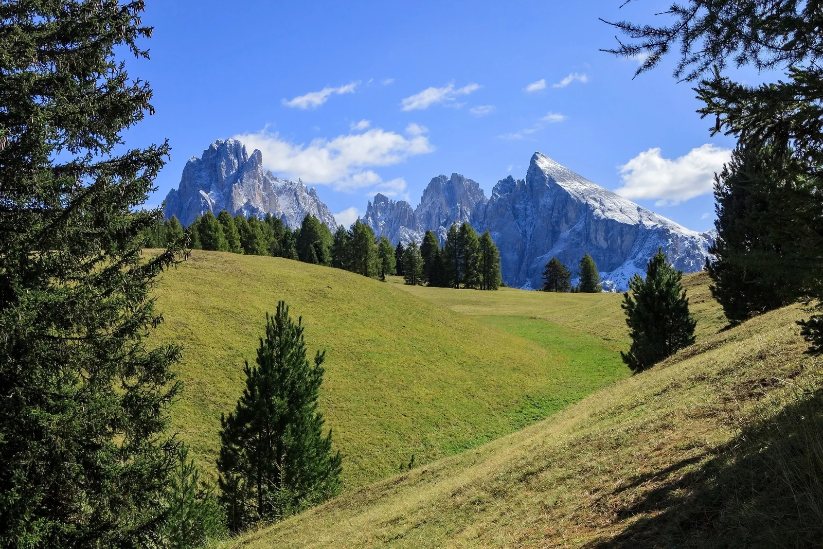
Gondolas climb from Ortisei and from Siusi, and Compatsch is the usual hub for walks. Private cars face daytime restrictions on the upper roads, so plan on lifts and local buses. In winter the same meadows become family-friendly ski terrain and cross-country trails. The Sciliar, a flat-topped massif on the southeastern edge, rewards a longer day with one of the area's classic panoramas.
Cortina d'Ampezzo and the Eastern Dolomites
Cortina d'Ampezzo, in the Veneto, hosted the 1956 Winter Olympics and still carries a more glamorous, Italian-feeling air than the South Tyrolean villages. A pretty pedestrian center sits inside a wide bowl of peaks, including the Tofane, Cristallo and Pomagagnon. Cable cars such as the one to Faloria give quick views over the town.
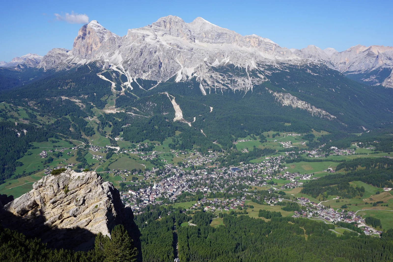
Cortina is a good base for the Tre Cime, Lagazuoi and the Cinque Torri area, and the surrounding valleys hold remnants of the First World War front, when the Dolomites were a battleground between Austro-Hungarian and Italian troops. Cortina also belongs to the Ladin-speaking world, where the local variety is called Anpezàn.
Hut-to-Hut Hiking and Via Ferrata
The Dolomites suit walking with a light pack. A dense network of mountain huts (rifugi) serves hot meals and offers dormitory or small-room beds, so you can walk from one to the next without a tent. The classic route is Alta Via 1, a multi-day trail that starts at Lago di Braies and finishes near Belluno, usually covered in roughly a week to ten days. Its highest point is at Rifugio Lagazuoi. The official Dolomiti tourism site describes the stages.
- Book huts ahead in July and August; many fill up well in advance.
- Carry cash in case card payments fail at remote huts, and check what each hut supplies.
- Start early. Afternoon thunderstorms are common in summer, and you want to be off the ridge by then.
- Check hut opening dates. Most close in late autumn and reopen in early summer.
Via Ferrata, in General Terms
A via ferrata ("iron way") is a protected climbing route with fixed steel cables, ladders and rungs. You clip into the cable with a harness and a shock-absorbing lanyard, and the line keeps you attached to the rock. Many Dolomite routes trace paths first equipped for soldiers in the First World War, and others were built later for recreation.
They range from easy cable-assisted trails to serious, exposed lines. Treat them as mountaineering, not a walk: you need a helmet, harness and ferrata set, a head for heights and decent weather. First-timers should go with a certified mountain guide, who can also supply gear. Check conditions and difficulty grades locally before you commit.
Summer and Ski Seasons
| Season | What it is like | Best for |
|---|---|---|
| Early summer (June) | Meadows in flower, some high paths still holding snow, some huts and lifts not yet open | Flowers, fewer people, valley walks |
| High summer (July and August) | Warmest weather, all lifts and huts open, biggest crowds and highest prices | Alta Via 1, high routes, via ferrata |
| Early autumn (September) | Clear air, calmer trails, cooler nights | Hiking without the rush, photography |
| Winter (December to March) | Snow cover, a huge ski circuit, many summer trails closed | Skiing, snowshoeing, Christmas markets |
In winter the Dolomiti Superski network links twelve ski areas with about 1,200 kilometers of slopes on a single pass, among them Val Gardena, Alpe di Siusi, Alta Badia and Cortina. The Sella Ronda, a ski circuit around the Sella massif, is the headline outing. Between seasons, in late spring and late autumn, many lifts and huts close, so a trip then needs extra checking.
Ladin Culture
Ladin is a Romance language that survives in the valleys around the Sella massif: Val Gardena, Val Badia, Val di Fassa, Livinallongo and Cortina d'Ampezzo, each with its own local variety. It is a recognized minority language, used in schools, signage and local media in the autonomous provinces. Speaker numbers are modest, a few tens of thousands, so hearing it spoken in a bakery or on a chairlift is part of the Dolomites' charm.
The culture shows up in food too. Look for hearty mountain dishes such as barley soup, dumplings (canederli or Knödel), speck and strudel, served with local wines from further down the valleys. For a wider sense of Italian regional food, see our Rome travel guide or head south to the Amalfi Coast.
Getting There and Around Without a Car
A car is convenient, but the Dolomites are workable on public transport, and some of the best spots, like Alpe di Siusi, restrict traffic anyway. The main gateways are Venice, Verona, Innsbruck and Bolzano, plus Munich for some South Tyrol routes.
- By train: the Brenner line reaches Bolzano and Bressanone, and the Pustertal line runs on to Dobbiaco (Toblach) and San Candido. Cortina has no station; the nearest are Dobbiaco and Calalzo di Cadore.
- By bus from Venice: direct coaches run between Venice airport and Cortina, taking roughly two to two and a half hours.
- Local buses: South Tyrol's SAD network and Dolomiti Bus in the Veneto link villages and trailheads. Many hotels give guests a regional transport pass, so ask when you book.
- Lifts and shuttles: many trailheads are reached by cable car or summer shuttle, so check timetables the evening before.
Stay in a village with good bus links: Ortisei or Selva for Val Gardena, Dobbiaco or San Candido for the Tre Cime and Braies, and Cortina for the east. Pick one valley and go deep rather than hopping between four. The mountains are close but the winding roads and buses make transfers slow. Planning a bigger trip across the border? Our Slovenia and Julian Alps guide is the natural next stop, and all of our European destinations are listed in one place.
Dolomites Travel Tips
- Weather turns fast. Carry a rain shell, warm layer, hat and gloves even in August.
- Respect the meadows. Stay on paths, close gates behind you and keep dogs under control near livestock.
- Mountain safety: tell someone your route, carry a map and check the forecast. The European emergency number is 112.
- Book early for July, August and winter weeks: lodging in small valleys is limited.
- Be flexible. Have a low-level plan B for cloudy or stormy days, such as a village market, museum or valley walk.
Dolomites Travel FAQ
When is the best time to visit the Dolomites?
For hiking, late June to mid-September is the main season, with July and August busiest. September is calmer and clear. For skiing, the lifts run roughly from December to March. Spring and late autumn are quiet, but many lifts and huts are closed.
Can you visit the Dolomites without a car?
Yes. Trains reach Bolzano, Bressanone and Dobbiaco, and regional buses and cable cars connect villages and trailheads. Direct coaches link Venice airport and Cortina. You need to plan around timetables, but car-free travel is realistic, especially if you base yourself in one valley.
How many days do you need in the Dolomites?
Five to seven days is a good first visit and lets you base in one or two valleys, with time for Braies, the Tre Cime and Seceda. Two or three days works for a single area. Alta Via 1 alone takes roughly a week or more.
Is Lago di Braies worth visiting despite the crowds?
Yes, if you plan around them. Arrive very early or late in the day, or choose June or September. Access in peak summer can be restricted, so check local rules first. Walking the shore loop takes about an hour.
Do you need experience for hut-to-hut hiking?
For routes like Alta Via 1, you need good fitness, proper boots and comfort with mountain weather, but not technical climbing skills. Book huts in advance for summer, pack light and expect long days with several hundred meters of climbing.
Is a via ferrata safe for beginners?
Easy routes can suit beginners, but only with the right gear (helmet, harness, ferrata set) and ideally a certified mountain guide. Never go without them. Check the grade, the weather and your fitness before you commit.
What language is spoken in the Dolomites?
It depends on the valley. German and Italian are both widely spoken in South Tyrol, Italian dominates in the Veneto and Trentino, and Ladin is used in valleys like Val Gardena, Val Badia and Fassa. English is usually fine in hotels and restaurants.