


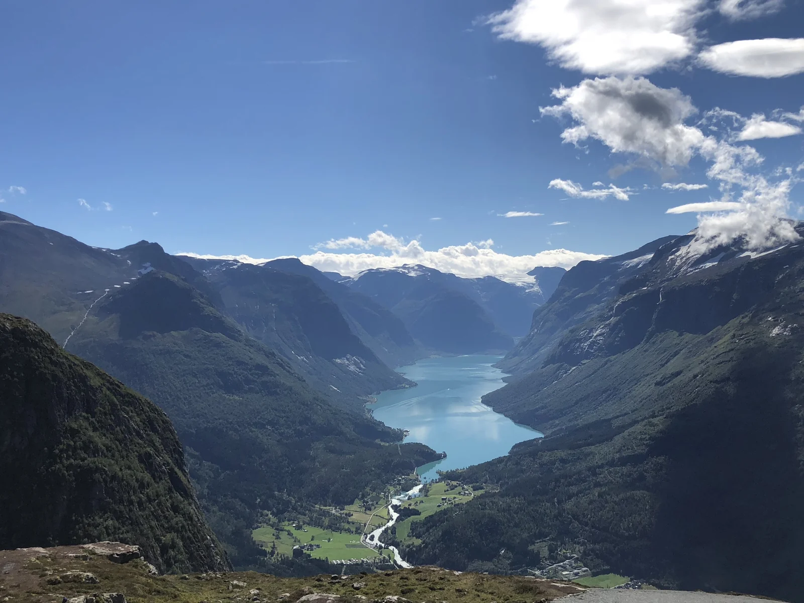
Lovatnet is a long, narrow lake in the Loen and Stryn area of western Norway, and it is one of the few places in the country where the water really does look turquoise. The color comes from meltwater that carries finely ground rock from the Jostedalsbreen glacier, and it is strongest on bright summer days. This guide to Lovatnet lake in Norway explains why it looks the way it does, what to do around it and how to fit it into a trip.
The lake is also tied to a hard piece of history. Two rockslides from the mountain Ramnefjellet, in 1905 and 1936, sent giant waves across the water and wiped out farms along the shore. Most visitors drive the quiet valley road, see the glacier at the end and take a short walk. Add the cable car above Loen and you have a full, varied day. For the wider region, see our Norway fjords and Lofoten guide.
If you are collecting turquoise lakes in Norway, Lovatnet is an easy one to reach and one of the least crowded, because most fjord tours skip the valley.
Why Lovatnet Is Turquoise
Glaciers act like slow sandpaper. As the ice moves, it grinds bedrock into a silt so fine that it stays suspended in meltwater instead of sinking. This is called glacial flour, or rock flour. When the water reaches a lake, the tiny particles scatter sunlight, and the lake reflects blue and green while absorbing the reds and yellows.
Lovatnet gets its flour from the Jostedalsbreen icecap, mainly through the Kjenndalselva river and several streams that tumble down the valley sides. The shade changes with the weather. After heavy rain or in peak melt, the lake can look milky and bright. On a gray day or later in the season it can look more green than blue. That is normal, and it is why two photos of the same lake can look like different places.
Lovatnet at a Glance
The basics are easy to check, and they help you picture the place before you go.
| Detail | What to know |
|---|---|
| Location | Stryn municipality, Vestland county, southeast of Loen |
| Size | Up to 11 km long and 1.5 km wide, roughly 10.5 km² in area |
| Elevation | About 52 m above sea level |
| Main inflow | The Kjenndalselva river, fed by Kjenndalsbreen and other meltwater |
| Outflow | The Loelva river, which runs north to the Nordfjord |
| Best for | Scenic drives, glacier viewing, short walks and photography |
Kjenndalsbreen: The Glacier at the End of the Valley
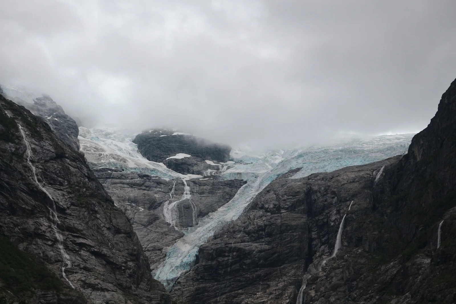
At the head of the valley sits Kjenndalsbreen, one of the arms of Jostedalsbreen. Jostedalsbreen is the largest glacier in continental Europe, covering roughly 487 km² and protected within a national park established in 1991. Kjenndalsbreen is among its lowest-lying arms, which is why you can reach it without any real mountaineering.
A road continues past the lake to Kjenndal, and the last stretch is a toll road. According to the Visit Norway listing, the viewpoint is roughly 17 km by car from Loen and the road closes in winter. From the parking area, the walk to the glacier viewpoint is short and easy, though ice is never a safe place to wander. Stay on the marked path and keep away from the glacier front, where ice and meltwater can move without warning.
The Kjenndalsbreen Hike
The classic Kjenndalsbreen hike is a gentle walk along the Kjenndalselva river and across moraine to a viewpoint below the ice. Local tourism sources put it at about 15 minutes from the car park, so it works for families and for anyone who wants a glacier without a long day. If you would rather make it more of an outing, you can park earlier and walk the last part of the valley road. The toll and the opening dates of the road change, so confirm them before you go.
Ramnefjellsfossen, the Waterfall Above the Lake
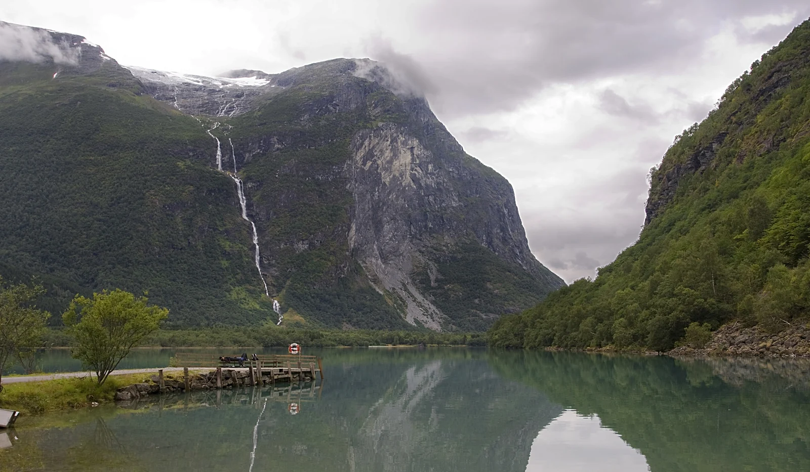
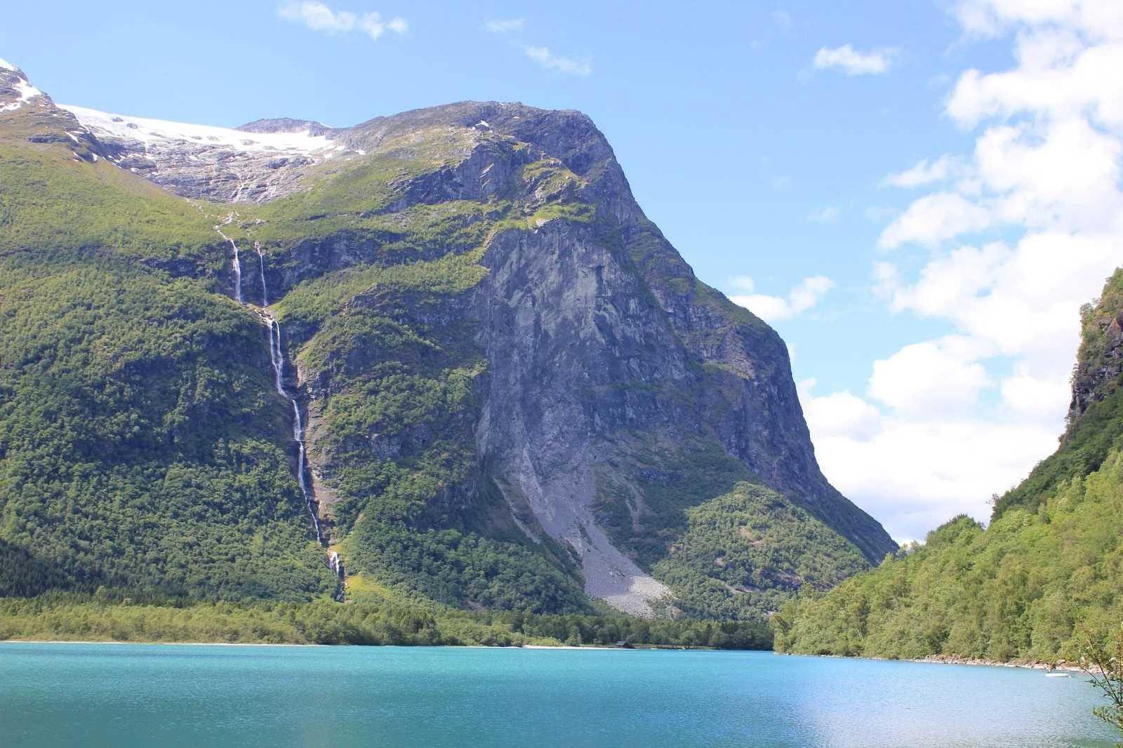
On the mountain side above the lake, Ramnefjellsfossen drops from the Ramnefjellet slopes, with a total height of 818 m spread over several drops, the longest single drop being about 405 m. You will often see it called the third-highest waterfall in the world, but that ranking is unofficial. A waterfall enthusiast database that includes smaller and seasonal falls places it eleventh. Whatever the ranking, it is a very tall, thin ribbon of water and one of the best sights on the drive.
The flow is highest in summer and can be thin after a long dry spell. You can see it from the road along the lake, so you do not need to hike to enjoy it.
The 1905 and 1936 Rockslide Tsunamis
Lovatnet is beautiful, and it is also a place of loss. On January 15, 1905, a huge mass of rock broke off Ramnefjellet and fell into the southern end of the lake. The largest wave reached about 40 meters, destroyed the farms at Nesdal and Bødal and killed 61 people, according to Visit Nordfjord.
Some families rebuilt farther up from the shore. On September 13, 1936, around 5 a.m., an even larger mass of rock, about one million cubic meters, came down from higher up the same mountain. The wave, which reached roughly 70 meters in the worst-hit spots, destroyed farms around the lake and killed 74 people. Houses built on higher ground after 1905 at Nesdal survived. The farms at Bødal and Nesdal were not rebuilt, and the disaster is described as Norway's largest natural catastrophe of the modern era.
What You Can See Today
The scar on the mountainside is still visible from parts of the road. A copper plaque beside the road between Bødal and Kjenndal lists the names of people whose bodies were never recovered after the two events. Take a moment there; it is a place of memory, not only a photo stop.
Loen Skylift and Hoven
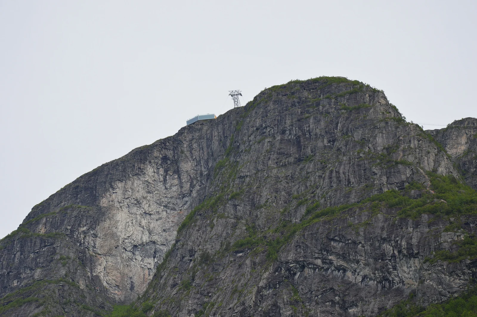
For a different view of the same lake, ride the Loen Skylift. The cable car opened in May 2017 and climbs from the fjord at Loen to the top of Hoven, 1,011 m above sea level, in about five minutes. From the summit station you see the Nordfjord on one side and, on a clear day, Lovatnet and its valley on the other.
Marked trails of varying difficulty start from the top, from simple gravel paths to rougher mountain terrain. The upper trails depend on snow, with the hiking season usually running from late spring to autumn, so check the official Loen Skylift site for operating status and hours. Weather up high can change fast.
How to Get to Lovatnet
Lovatnet is a drive-to place. A rental car makes life easiest, and the lake road is the heart of the visit. Loen sits on the Nordfjord, and most travelers arrive from Bergen, from Ålesund or over the mountains from Geiranger.
| Starting point | Approximate trip to Loen | Notes |
|---|---|---|
| Bergen | Roughly 5 hours or more by car | Long drive with at least one ferry; plan a stop on the way |
| Ålesund | About 2 to 3 hours by car | Includes a short ferry across Storfjorden |
| Ålesund Airport (Vigra) | Allow roughly 2.5 to 3 hours by road | The nearest large airports are Ålesund and Bergen; check coach and rental car options |
| Geiranger | A mountain road toward Stryn | Check road and ferry status before you set out |
From Loen, follow the signs toward Lodalen and Lovatnet; the road runs along the lake and on to Kjenndal. It is narrow in places, so drive slowly and use the pull-outs for photos. If you are combining Lovatnet with Geirangerfjord, our Bergen to Geiranger guide covers the wider route. Exact driving times vary with ferries and roadwork.
Loen Norway Things to Do: Drives, Walks and Hikes
Boats on the Lake
A boat trip has been offered on the lake in summer in past years, which is a relaxed way to see the waterfall and the steep walls of the valley. Ask the Nordfjord tourist office or your hotel whether sailings are running this season, since they depend on weather and demand.
Walking and Paddling
The flat water can suit paddlers in calm weather, but rentals are not something to count on, so ask locally before you plan around them. Cold meltwater and sudden wind are real risks, so wear a life jacket. On land, the road beside the lake works well for a long walk or a bike ride, with the café at Kjenndalsstova, open roughly May to September, as a goal.
Other Stops Nearby
Loen sits close to Olden and Briksdalsbreen, another arm of Jostedalsbreen, and to the town of Stryn. A day for Lovatnet and a second day for Hoven and the fjord is a comfortable plan. Guided mountain activities also start from Loen in summer. More ideas are in our Norway travel guides and the wider European destinations.
Best Time to Visit Lovatnet
- June to August: the road and the café are open, the waterfall runs strongly and the water is at its brightest. This is also the busiest period.
- May and September: quieter, with a good chance of clear days, although some services run on reduced schedules.
- October to April: the Kjenndal road is closed in winter and the café is shut. The lake is still beautiful, but you will see less of it.
Plan on rain at any time; this is one of the wetter parts of Norway. Bring a waterproof jacket and layers, even in July.
Where to Stay Near Lovatnet
You do not need a specific hotel to enjoy the lake. Think in terms of areas.
- Loen: the most convenient base, with the cable car, the fjord and the start of the lake road.
- Olden: a short drive away, useful if you want Briksdalsbreen too.
- Stryn: a larger town with more services, restaurants and shops.
- Farm stays and cabins along the Nordfjord: quiet and good for families; book early for summer.
Is There a Blue Lagoon in Norway?
Some travelers land on Lovatnet while searching for a blue lagoon in Norway. Norway has no geothermal spa like Iceland's Blue Lagoon, because it lacks the volcanic heat that feeds it. What it has instead are glacial lakes such as Lovatnet and blue-green fjord water that people sometimes compare to a lagoon. Our article on Norway's blue lagoon explains what people actually find under that name.
Lovatnet FAQ
Why is Lovatnet turquoise?
Meltwater from the Jostedalsbreen glacier carries glacial flour, extremely fine rock ground by moving ice. The particles scatter sunlight and give the lake its turquoise tint, which shifts with weather and season.
How do you get to Lovatnet from Loen?
Drive southeast from Loen on the road into Lodalen. It follows the lake to Sande and continues to Kjenndal. The last stretch is a toll road that closes in winter, so confirm tolls and opening before you go.
How long is the Kjenndalsbreen hike?
The walk from the parking area to the viewpoint is short, about 15 minutes according to local tourism sources. It is easy and suits families, but stay on the marked path and away from the ice.
What happened at Lovatnet in 1905 and 1936?
Rockslides from Ramnefjellet fell into the lake and created huge waves. The 1905 wave killed 61 people, and the larger 1936 slide killed 74. The farms at Bødal and Nesdal were never rebuilt.
When is the best time to visit Lovatnet?
June to August is best for an open road, the café and a strong waterfall. May and September are quieter. The Kjenndal road closes in winter, so services stop outside the summer season.
Is the Loen Skylift worth it?
Yes, if the weather is clear. The five-minute ride rises to Hoven at 1,011 m, with wide views of the Nordfjord and the Lovatnet valley, plus marked trails. Check the official site for operating status.
Can you swim in Lovatnet?
The water is glacial meltwater and stays very cold, so swimming is for the brave and best kept short and close to shore. Use caution, avoid swimming alone and check local advice first.
Where is Lovatnet located?
Lovatnet is a long, narrow lake in the Loen and Stryn area of western Norway, in the Nordfjord region. It lies in a valley reached by road from Loen, and most visitors arrive from Bergen, from Ålesund or over the mountains from Geiranger.
How high is Ramnefjellsfossen waterfall?
Ramnefjellsfossen drops from the Ramnefjellet slopes toward the lake with a total height of 818 meters spread over several drops. The longest single drop is about 405 meters. Flow is highest in summer and can be thin after a long dry spell. You can see it from the lake road.
Is Lovatnet crowded?
Not usually. Lovatnet is one of the least crowded turquoise lakes in Norway, because most fjord tours skip the valley. It is a drive-to place, so a rental car makes the visit easiest. The narrow road has pull-outs, so drive slowly and let others pass.